
Deteriorating road conditions on NH Route 16 called for more knowledge about what was happing under the roads surface. HEB Engineers contracted Infrasense, Inc. and Radar Solutions International, Inc. (RSI) to investigate the depth and lateral extent of the concrete below the asphalt.
In early December 2014, President and Senior Geophysicist Doria Kutrubes, Geophysical Technician Rick Lammey and Infrasense's Civil Engineer Evan Guarino, completed a concrete survey using two geophysical techniques.
To determine the presence of concrete and asphalt thickness, Even used GSSI's SIR-3000 and an air coupled 1.5 GHz antenna. To supplement the 1.5 GHZ antenna, Doria and Rick scanned the road with GSSI's SIR-3000 and 400 MHZ antenna. Using each of these methods we were not only able to determine the presence of concrete, but also identified other sub-surficial features like utilities and voids.
The figure below left only shows the areas of different concrete compositions as determined by the 1.5 GHz and 400 MHZ antennas. As previously mentioned, we also determined the location of utilities and voids using both geophysical methods. The image below right shows an example of a void from the 400 MHz data. We calculated the dielectric constant of the pavement with the use of the 1.5 GHz air coupled antenna. Areas with high dielectric values were indicative of patches from utility installations. The visual inspection of the data also located voids and utilities cutting across the road. However, it is still undetermined the kind of utilities that are located beneath the road.
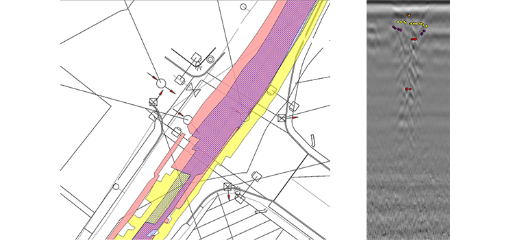
Above left: A sample of completed results from both the 400 MHZ and 1.5 GHz data sets.
Above right: An example of a void from the 400 MHz data.
Acknowledgement: We would like to thank the HEB staff for their assistance during the field work collection phase and the background knowledge of the area that helped us reduce the data.