
Radar Solutions International, a Massachusetts based WBE/DBE certified firm, was founded in July 1996 by then sole proprietor Doria Kutrubes, with the purpose and passion of using geophysical methods to help people improve their living environment by using geophysics to detect sources of contamination and finding new, potable water supplies. Since then, RSI has grown from a one woman firm, to a five person S-Corporation; incorporated on 1/6/2012. Radar Solutions International, Inc. continues to provide the highest quality, advanced geophysical services to help a broad spectrum of needs for environmental, engineering, construction, infrastructure and archaeological clientele along with government agencies and our communities. Our services are classified under the Federal Government NAICS codes 541360, 541330, 561990 and include such services as:
-Utility locating/surveying and mapping using GPR, EMI and other EM methods for entire sites where as-built information is unknown or inaccurate, or to clear individual borings/monitoring well locations.
-Locating UST's, drums, lagoons and other sources of contamination using multiple geophysical techniques.
-Mapping/tracing contamination as it migrates through the soil and bedrock using GPR and other EM methods.
-Hydrogeological and landfill characterizations.
-Water supply and water quality studies.
-Bedrock depth and topography surveys for geotechnical assessment of foundation conditions or as part of locating the deepest possible area for construction.
-Foundation, footing and pier depths and condition assessments (cell phone towers, buildings, dams, granite block abutments, wing walls) using GPR and a variety of sonic methods.
-Geotechnical assessments of soils and foundation conditions using seismic refraction and/or tomography.
-Location of structural steel, rebar and post-tension cables in concrete structures, bridges and pavement.
-Location and depth of conduits within and immediately below concrete slabs and structures prior to coring or saw-cutting.
-Concrete condition assessment using GPR, impact echo and slab IR.
-Void detection within and below columns and slabs. Structural assessment of concrete column, beams, girders, joist and structural slabs.
-Geophysical surveys in support of archaeological investigations.
With our state-of-the-art GPR, geophysical equipment and software processing and imaging packages, RSI is able to accurately image underground utilities, UST's and other targets then present them as final deliverable (maps) in AutoCAD, ARCGIS, Acrobat PDF and Google Earth formats. We serve all of the U.S., but most of our business is within the New England and New York Regions, accessing jobs sites from our offices in Waltham, MA., Albany, N.H. and Dallas, TX. As our name implies, we also travel internationally to provide GPR services, consulting, training along with other geophysical techniques. RSI always welcomes inquiries regarding our services or how geophysics can be used to solve a particular problem.
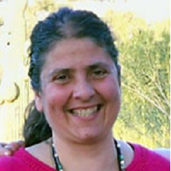
Ms. Kutrubes has nearly 40 years of experience in the applications of geophysical surveying and mapping (NAICS 541360, 541330 (geophysics only) to environmental, engineering, geotechnical, infrastructure, hydro-geological, and archaeological applications. Since 1984, she has performed investigations for locating and mapping underground storage tanks, utilities, hazardous waste and contaminant plumes, bedrock topography, concrete deterioration and other structural slab and pavement related applications, and archeological/ forensic studies at thousands of sites throughout New England, United States and internationally. In 1989 Ms. Kutrubes drafted the SOPs for GPR, and helped write the SOPs for EM, magnetic, resistivity, and other methods for the MADEP (formerly MA DEQE). She has served on two FHWA TRB SHRP II Initiatives, one in developing a toolbox approach for mapping concrete deterioration, and the other for mapping utilities (2009). Ms. Kutrubes received her M.Sc. in Geophysical Engineering, with a concentration in Hydrogeology, from the Colorado School of Mines and her B.Sc. in Geology from Bates College.
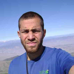
Mackenzie joined the RSI team part-time in the spring of 2010, and full-time in June 2016. Mackenzie’s geophysical work has included projects covering utility surveying and mapping, infrastructure development and repair, environmental remediation and monitoring, structural engineering, archaeological investigation, and other geotechnical applications. Mr. Kilpatrick has worked on hundreds of utility surveying and mapping projects, including ASTM Levels A and B surveys and employed the full suite of geophysical methods. He has used GPR and EMI to clear thousands of borings for environmental and geotechnical applications. Mackenzie has a M.Sc. in Geography from the University of Nevada, Reno and a B.A. from the University of New Hampshire. Mackenzie has expertise in GIS, image analysis, spatial statistics, and has field experience ranging from New England to extensive field work in the remote deserts and mountains of California, Utah, and Nevada. Mackenzie is currently an Engineer Officer in the California Army National Guard.
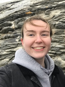
Emily joined the RSI team in the summer of 2022. Her work at RSI has included utility surveying and mapping throughout the Northeast. She has worked to survey voids, rebar, post-tension cables, and underground storage tanks both indoors and outdoors. Emily has also worked on multiple archaeological and forensic burial surveys, bedrock surveys, and she has assisted on many surveys to determine slab and foundation depth and integrity. She superimposes any client maps onto site aerial imagery with geophysical results for an easy-to-view deliverable. She also overlays GPR, EM, and EMI survey results on LiDAR and GPR data for a full 3D view of any site. Emily graduated from Bates College with a B.S. in Geology, minor in physics, and concentration in field studies. She has a strong background in GIS, geochemistry, hydrology, and wetlands.
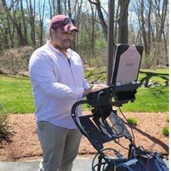
Cameron joined the RSI team in the spring of 2014, and since then has completed hundreds of Geophysical Surveying and Mapping projects for surveying and mapping of utilities (ASTM SUE LEVELS A, B, and C), thousands of borehole clearances prior to installation of environmental and geotechnical wells and borings, hundreds of void surveys, including those to assess slab integrity and structure using ultra-sonic methods, and dozens of surveys at historic cemeteries looking for unmarked graves. His strong GIS background has enabled RSI to push the boundaries of RSI’s deliverables, producing 3D utility, void, and bedrock elevation maps, superimposed onto our clients’ DEMs and AutoCADs. In 2019, because of his contributions to innovations at RSI, Cameron became a minority-share owner of RSI, and with it, assumed the position of Vice President and Geophysical Associate. Mr. Russ was instrumental in helping RSI to become one of the first companies to combine LiDAR and GPR data, so clients can envision their data above and below the ground. Cameron graduated Bates College with a B.S. in Geology and a concentration in Physics. His strong GIS background has aided in our interfacing between GPS and Geophysical Data, adding to the strength of the RSI team.
Rick joined the RSI as a Geophysical Technician in June of 2013. Rick has a very strong technical background, having previously worked as a technician in the electronics and telecommunications industry for over 13 years. He is very knowledgeable in both the construction and environmental industries. Rick has collected field data for RSI throughout New England and the Northeast using GPR, EMI, EM-61 and GPS on hundreds of projects along with being highly competent of interpreting real-time GPR data in the field. For the past 12 years, Rick has been leading on providing DIG-SAFE services for the University of New Hampshire in Durham, NH and at General Electric in Lynn, Ma. for the last 6 years. He has assisted with on-call DIG-SAFE request from commercial and private clients throughout New England. Rick is a member of the NH Chapter of the AMC, The Maine Island Trail Association and is current Treasurer and Charter Member of the Conway Area Lions Club for the last 3 years. On top of being treasurer, he also has the marketing and webmaster roles for them. Rick has received the "NH Granite State Fellow" Award and the "LCI Melvin Jones" Award from the Lions Club.