
In 373 BC, the Classical city of Helike, on the southern shore of the Gulf of Corinth in Greece, was destroyed by a catastrophic earthquake, mass-movement of the deltaic sediments upon which it was built, and a large tidal wave (tsunami) which immediately ensued. Due to subsequent burial by sedimentation, and tectonic uplift of the northern Peloponnesos, the ruined site is now believed to be on land, possibly a few kilometers southeast of Aigion, in the area of the coalesced deltas of the Selinous, Kerynites, and Vouraikos Rivers. Since 1988, the search for Helike has been conducted by the Directors of the Helike Project, Dr. Steven Soter and Dr. Dora Katsonopoulou.
In the Summer of 1996 Doria Kutrubes, Geophysicist and President of Radar Solutions, directed a ground penetrating radar (GPR) survey in seven areas near the presumed site of Helike. She was assisted by Dr. Steven Soter, currently with the American Museum of Natural History in New York, New York, Dr. Dora Katsonopoulou, of the American School of Classical Greek Studies, Athens, Greece, and other Friends of the Helike Project, Joan Friedman, Maria Argyropoulou, and Maria Stefanopoulou.
Data collected using GSSI's SIR-2 and monostatic 400 MHz antenna achieved a maximum penetration of 3 m, observing several hyperbolic targets. One of these was a tile floor dating from the Roman Era (pictured below), located at a 1.4 meter depth. In another area, many of these hyperbolic reflectors were aligned over a 40 meter distance, suggesting the presence of an ancient wall. GSSI's multi-low-frequency biostatic antenna, used in the 80 MHz configuration, achieved depths of approximately 5 to 6 meters in some areas. Data from these surveys are still being evaluated for purposes of 2D and 3D imaging.
During the summer of 1997, numerous boreholes were conducted to ground-truth observed GPR anomalies and to determine the depth to the Classical Helike horizons. The 40 meter long linear feature was confirmed to be an ancient wall, likely from Classical Greek times. The wall, shown below, was composed of small boulders and cobbles cemented together with mortar. The wall appears to be over 1.5 meters high and 80 cm wide. The top of the wall is less than 90 cm below grade in some locations where local farming and soil removal had occurred.
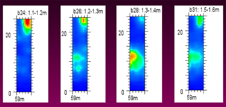
ABOVE: 3D depth slices revealing a Roman era tile floor over a meter below the surface.
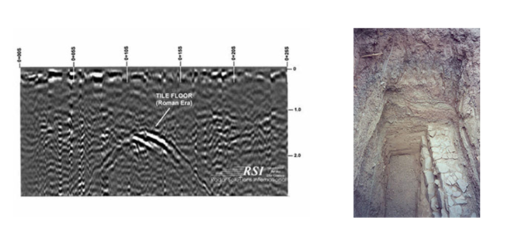
ABOVE LEFT: One dimensional GPR record of the same Roman era tile floor, collected using a GSSI 400 MHz antenna. This and other GPR data were gathered by geophysicist Doria Kutrubes, of Radar Solutions International, Inc.
ABOVE RIGHT: Roman era basin, showing the type of tiled floor discovered in the Helike Project using GPR.
During the summer of 1997, numerous boreholes were conducted to ground-truth observed GPR anomalies and to determine the depth to the Classical Helike horizons. The 40 meter long linear feature was confirmed to be an ancient wall, likely from Classical Greek times. The wall, shown below, was composed of small boulders and cobbles cemented together with mortar. The wall appears to be over 1.5 meters high and 80 cm wide. The top of the wall is less than 90 cm below grade in some locations where local farming and soil removal had occurred.
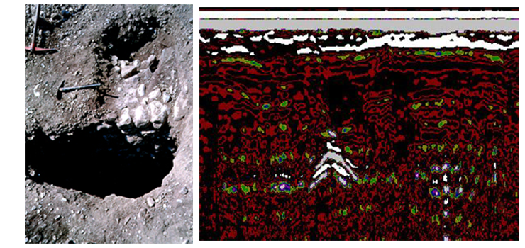
GPR records recorded from data acquired transverse to the wall's long axis ( ABOVE LEFT) produced high-amplitude hyperbolic reflectors, similar to that observed on the GPR record (ABOVE RIGHT). This particular GPR record was obtained during the Summer of 1998 from another area were high-amplitude hyperbolic reflectors were observed along a 150 meter long alignment. Speculation suggests the presence of yet another, larger wall, possibly the wall surrounding the ancient City of Helike, itself.
Ms. Kutrubes and Dr. Soter returned to Greece during the Summer of 1998 to continue with GPR, and magnetic surveys. Data from these surveys have partially been interpreted. Some information has been presented at various conferences attended by Dr. Soter and Dr. Dora Katsonopoulou.
Additional Acknowledgments: We also wish to thank Geophysical Survey System, Inc. for the use of their multi-low frequency antenna.